Showing posts with label Geology. Show all posts

2019-04-08

GeoMapApp - freeware GIS system linked to geological datasets pasted from main blog


GeoMapApp (www.geomapapp.net) is a Java tool (read : runs on any powerful-enough system) for interrogating various publicly available geological and geophysical data sets as well as your own data sets, then displaying the data together.
My current task - I wish to plot seabed terrain between West Africa and North Brazil, to show the potential for a "chain-of-beads" linkage for not-fully marine whales to cross the proto-Atlantic.
But now I'm tired.

The Brazilian archipelago has a lighthouse and research station at 0°55'00.4"N / 29°20'45.1"W ( 0.916764 / -29.345849 ) surrounded by 5 islets comprising nearly 12000 sq.m of exposed land. That is equivalent to about 120 m in diameter, and unsurprisingly, the 250m typical resolution of the bathymetry and coastlines global datasets don't show it.

That explains why I can't manually position a profile line across the islands. Which is unfortunate. Since multiple-leg profiles are not supported, I'll have to resort to a little subterfuge. Two approaches suggest themselves - manually calculating two end-points that pass over my desired point and looking at that, or constructing a profile from one point to my location then a second profile from my location to another point. The second method would allow construction of "dog-leg" profiles.


OK, now I've forgotten how to do images on the blog, and I've just trashed the last edit.
More JS permissions needed.


Now, having set up the profiles with identical horizontal and vertical scales, I could bodge those profiles together, end to end, to make a single profile, and edit the maps to show it properly on one. Do-able, but a lot of fankle. Alternatively, I can try to work out how to make a GIS "shapefile" (which is opening up a whole can of GIS worms itself) to produce the map plot, and export the two profiles as data files, merge them in a spreadsheet, and do the plot from the spreadsheet (I can also manually correct the StPeter-StPaul rocks elevation to match the 18m of record. It's below the resolution of the dataset.) That's a lot of work for a whim.

https://en.wikipedia.org/wiki/Saint_Peter_and_Saint_Paul_Archipelago
00°55′1″N 29°20′45″W

2014-12-09

Decoding a hallmark

A hallmark is a set of marks made on a piece of precious metal to indicate it's quality, as verified by a particular assay office.
The hallmark normally contains - an indication of the controlling assay office (a national body, or a local one for a city or region) - the type and quality of the metal - the manufacturer - and frequently an indication of the date of manufacture. Naturally this information is of great interest to the  dealer in antiques and jewellery. Naturally therefore they are also prone to being forged. For a long time then, the stamps used to make these marks were very fine pieces of the metalworker's art, to discourage copying by unauthorised people. Again, this makes them a target for forgery.

I have been examining a ring which I brought from a jewllers as Oksana's engagement ring. I got the size drastically wrong - it was the first ring I ever brought - and it has long needed to be rebuilt to fit her much smaller fingers. And in the process, I've been examining the hallmarks.
Well, I can get something out of that :
- the 4th character is a 5-petaled Yorkshire rose - which is the symbol for the Sheffield assay office.
- the boxed "375" is the gold count in parts per thousand. 375/1000  is 3 parts in 8, or 9-carat.

The rest of the symbols - I need to take a closer photo (and the ring is currently at the jewellers), or get the sketchbook and loupe out.

2005-11-28

Day in the (death) of a worm

Click for full-size image?
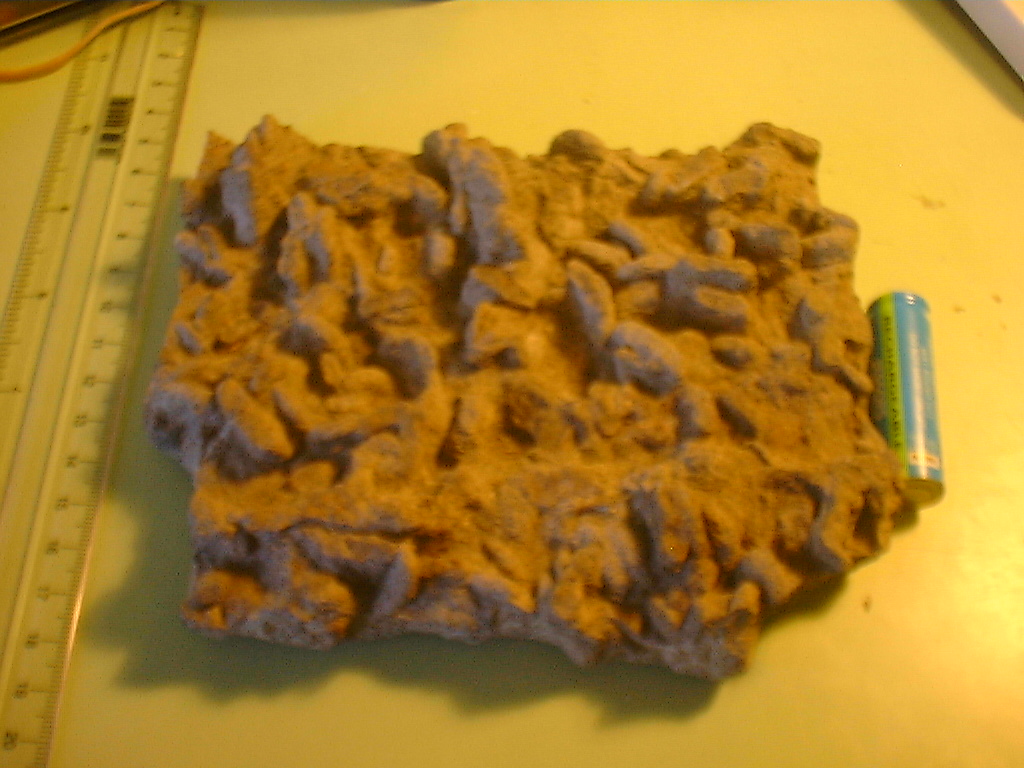
Just been digging around in the rock pile, and I found this rock which I'd recently described in a USENET post:

The cohesiveness of consolidated mud would 
provide a comparatively resistant surface over
which coarser-grained sediments could be
transported as a package.
Actually, thinking about it, I've a nice specimen
in my rock pile showing a similar event from
100-odd million years ago. Mid-jurassic of the
Isle of Wight, there was a muddy sea-bottom
with a rich fauna of burrowing worms chomping
away buried in their nice muddy burrows. Then
along came a flood of silty sand which buried
and killed off the worms leaving a series of
sandy casts of the top ends of the burrows on
the *under* surface of a circa-2cm thick sand
bed.
One hundred million years later along comes a
superannuated hippie of a geology student who
extracts said thin sand bed from a 10-odd metre
high cliff of similarly interbedded muds and
sands, and carefully appreciates the day in
the death of these worms before spending
hours in the pub (and back in the honours
year student labs) carefully picking out the
bits of clay from between the casts of the
burrows.

"AA" size cell and a ruler to give scale objects. The autofocus of the camera seems to be slipping, and there's no manual alternative. I'm thinking that I can almost justify getting a new camera.

2005-11-29
Carsten described these as "escape structures". I don't think so - I think they're burrows which the worms (lugworm or equivalent) died in after getting a belly full of sand. The underlying mudstone bed contains sub-vertically oriented sand tubes dispersed through the mud, representing the worms which swallowed a sand meal, stopped eating, swallowed (separating the swallowed sand from the continuous sheet), then died.
Please note that this photograph is of the UNDERSIDE of the slab as originally found, in a normally oriented sediment sequence.